 Weather Center |
|
|
|
|
X
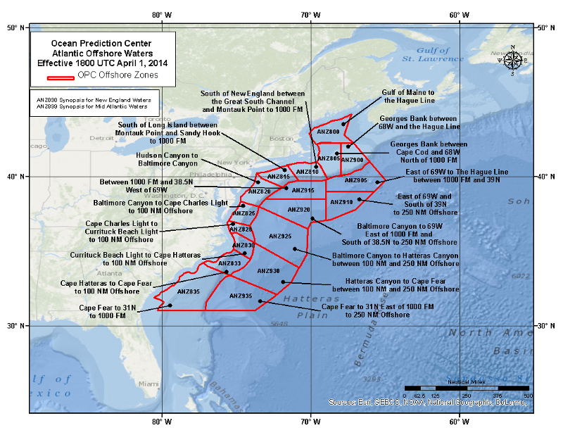
ANZ800: Gulf of Maine to the Hague LineExpires:202603032045;;543479 FZNT21 KWBC 030825 OFFNT1 Offshore Waters Forecast NWS Ocean Prediction Center Washington DC 325 AM EST Tue Mar 3 2026 New England continental shelf and slope waters from 25 nm offshore to the Hague Line, except to 1000 fm south of New England. Seas given as significant wave height, which is the average height of the highest 1/3 of the waves. Individual waves may be more than twice the significant wave height. Locally higher winds and seas can be expected in and near tstms. ANZ800-032045- Gulf of Maine to the Hague Line- 325 AM EST Tue Mar 3 2026 .TODAY...S to SW winds 15 to 25 kt. Seas 3 to 6 ft. Light freezing spray in the morning. .TONIGHT...S to SE winds 15 to 25 kt, becoming W to SW. Seas 5 to 8 ft. Chance of rain with vsby 1 nm or less. .WED...W to NW winds 10 to 20 kt, becoming W to SW 5 to 15 kt. Seas 4 to 8 ft. .WED NIGHT...SW winds 5 to 15 kt, becoming E to SE 5 to 10 kt. Seas 3 to 6 ft. .THU...E to NE winds less than 10 kt, becoming NE 10 to 20 kt. Seas 3 to 5 ft. .THU NIGHT...E to NE winds 15 to 25 kt. Seas 4 to 7 ft. .FRI...E winds 20 to 30 kt. Seas 6 to 10 ft. .FRI NIGHT...E winds 15 to 25 kt. Seas 6 to 11 ft. .SAT...SE winds 10 to 15 kt, becoming S 10 to 20 kt. Seas 5 to 8 ft. .SAT NIGHT...SW winds 20 to 25 kt. Seas 6 to 8 ft. $$
X
ANZ805: Georges Bank between Cape Cod and 68W north of 1000 fmExpires:202603032045;;543480 FZNT21 KWBC 030825 OFFNT1 Offshore Waters Forecast NWS Ocean Prediction Center Washington DC 325 AM EST Tue Mar 3 2026 New England continental shelf and slope waters from 25 nm offshore to the Hague Line, except to 1000 fm south of New England. Seas given as significant wave height, which is the average height of the highest 1/3 of the waves. Individual waves may be more than twice the significant wave height. Locally higher winds and seas can be expected in and near tstms. ANZ805-032045- Georges Bank between Cape Cod and 68W north of 1000 FM- 325 AM EST Tue Mar 3 2026 .TODAY...S to SE winds 5 to 10 kt, increasing to 15 to 20 kt. Seas 3 to 5 ft. Light freezing spray in the morning. .TONIGHT...S to SE winds 20 to 30 kt, becoming W to SW. Seas 6 to 10 ft. Chance of rain with vsby 1 nm or less. .WED...W winds 10 to 15 kt, becoming variable. Seas 5 to 9 ft. Chance of rain and areas of fog with vsby 1 nm or less. .WED NIGHT...S to SW winds less than 10 kt, becoming variable. Seas 4 to 6 ft. Areas of fog with vsby 1 nm or less. .THU...Variable winds less than 10 kt. Seas 3 to 5 ft. .THU NIGHT...E winds 5 to 15 kt, increasing to 15 to 25 kt. Seas 4 to 7 ft. .FRI...E to NE winds 20 to 30 kt. Seas 6 to 10 ft. .FRI NIGHT...E to NE winds 15 to 25 kt, diminishing to 5 to 15 kt. Seas 8 to 10 ft. .SAT...E winds less than 10 kt, becoming S. Seas 6 to 8 ft. .SAT NIGHT...SW winds 15 to 25 kt. Seas 6 to 8 ft. $$
X
ANZ810: South of New England between the Great South Channel and Montauk Point to 1000 fmExpires:202603032045;;543482 FZNT21 KWBC 030825 OFFNT1 Offshore Waters Forecast NWS Ocean Prediction Center Washington DC 325 AM EST Tue Mar 3 2026 New England continental shelf and slope waters from 25 nm offshore to the Hague Line, except to 1000 fm south of New England. Seas given as significant wave height, which is the average height of the highest 1/3 of the waves. Individual waves may be more than twice the significant wave height. Locally higher winds and seas can be expected in and near tstms. ANZ810-032045- South of New England between the Great South Channel and Montauk Point to 1000 FM- 325 AM EST Tue Mar 3 2026 .TODAY...E to SE winds 5 to 10 kt, becoming SE 15 to 25 kt. Seas 4 to 7 ft. .TONIGHT...S to SW winds 15 to 25 kt, becoming W to SW. Seas 6 to 10 ft. Slight chance of rain with vsby 1 nm or less. .WED...W winds 5 to 15 kt, becoming variable. Seas 5 to 8 ft. Areas of fog and chance of rain with vsby 1 nm or less. .WED NIGHT...Variable winds less than 5 kt. Seas 4 to 6 ft. Areas of fog with vsby 1 nm or less. .THU...Variable winds less than 5 kt, becoming E to NE. Seas 3 to 4 ft. .THU NIGHT...E winds 5 to 15 kt. Seas 3 to 5 ft. .FRI...E to NE winds 10 to 20 kt. Seas 5 to 8 ft. .FRI NIGHT...NE winds 10 to 20 kt, becoming N to NE 5 to 10 kt. Seas 5 to 9 ft. .SAT...Variable winds less than 5 kt, becoming S. Seas 5 to 8 ft. .SAT NIGHT...SW winds 10 to 15 kt, increasing to 15 to 20 kt. Seas 5 to 8 ft. $$
X
ANZ815: South of Long Island between Montauk Point and Sandy Hook to 1000 fmExpires:202603032045;;543483 FZNT21 KWBC 030825 OFFNT1 Offshore Waters Forecast NWS Ocean Prediction Center Washington DC 325 AM EST Tue Mar 3 2026 New England continental shelf and slope waters from 25 nm offshore to the Hague Line, except to 1000 fm south of New England. Seas given as significant wave height, which is the average height of the highest 1/3 of the waves. Individual waves may be more than twice the significant wave height. Locally higher winds and seas can be expected in and near tstms. ANZ815-032045- South of Long Island between Montauk Point and Sandy Hook to 1000 FM- 325 AM EST Tue Mar 3 2026 .TODAY...E winds 10 to 15 kt, becoming SE early, then, becoming 10 to 20 kt. Seas 4 to 7 ft. .TONIGHT...W to SW winds 10 to 20 kt. Seas 4 to 8 ft. Slight chance of rain with vsby 1 nm or less. .WED...W to NW winds 5 to 15 kt, becoming variable less than 5 kt. Seas 4 to 7 ft. Chance of rain and areas of fog with vsby 1 nm or less. .WED NIGHT...Variable winds less than 5 kt. Seas 4 to 5 ft. Areas of fog with vsby 1 nm or less early. .THU...Variable winds less than 5 kt, becoming E. Seas 3 to 5 ft. .THU NIGHT...E winds 5 to 15 kt. Seas 3 to 5 ft. .FRI...NE winds 5 to 15 kt, becoming N to NE 10 to 20 kt. Seas 5 to 6 ft. .FRI NIGHT...NE winds 15 to 20 kt, becoming E to NE 5 to 10 kt. Seas 4 to 7 ft. .SAT...E to SE winds less than 5 kt, becoming S. Seas 4 to 7 ft. .SAT NIGHT...SW winds 10 to 15 kt, increasing to 15 to 25 kt. Seas 5 to 8 ft. $$ .Forecaster Kells. Ocean Prediction Center.
X
ANZ820: Hudson Canyon to Baltimore Canyon to 1000 fmExpires:202603032045;;543546 FZNT22 KWBC 030828 OFFNT2 Offshore Waters Forecast NWS Ocean Prediction Center Washington DC 328 AM EST Tue Mar 3 2026 West central North Atlantic continental shelf and slope waters beyond 20 nm to 250 nm offshore, including south of Georges Bank from 1000 fm to 250 nm offshore. Seas given as significant wave height, which is the average height of the highest 1/3 of the waves. Individual waves may be more than twice the significant wave height. Locally higher winds and seas can be expected in and near tstms. ANZ820-032045- Hudson Canyon to Baltimore Canyon to 1000 FM- 328 AM EST Tue Mar 3 2026 .TODAY...E winds 10 to 20 kt, becoming S to SE. Seas 4 to 7 ft. Rain likely with vsby 1 nm or less. .TONIGHT...SW winds 10 to 20 kt. Seas 4 to 8 ft. Slight chance of rain. Areas of fog. Vsby 1 NM or less. .WED...W winds 5 to 15 kt, becoming variable less than 5 kt. Seas 4 to 7 ft. Areas of fog and chance of rain with vsby 1 nm or less. .WED NIGHT...Variable winds less than 10 kt. Seas 3 to 5 ft. Areas of fog early. Chance of showers. Vsby 1 NM or less. .THU...S to SW winds 5 to 10 kt, becoming 5 to 15 kt. Seas 3 to 5 ft. .THU NIGHT...S to SW winds 5 to 15 kt, becoming SW 10 to 20 kt. Seas 3 to 5 ft. .FRI...W to SW winds 5 to 15 kt, becoming N to NE 10 to 20 kt. Seas 4 to 6 ft. .FRI NIGHT...NE winds 10 to 20 kt, becoming E 5 to 10 kt. Seas 4 to 6 ft. .SAT...S to SE winds 5 to 10 kt, becoming S to SW. Seas 4 to 6 ft. .SAT NIGHT...S to SW winds 15 to 25 kt. Seas 4 to 7 ft. $$
X
ANZ900: Georges Bank between 68W and the Hague LineExpires:202603032045;;543481 FZNT21 KWBC 030825 OFFNT1 Offshore Waters Forecast NWS Ocean Prediction Center Washington DC 325 AM EST Tue Mar 3 2026 New England continental shelf and slope waters from 25 nm offshore to the Hague Line, except to 1000 fm south of New England. Seas given as significant wave height, which is the average height of the highest 1/3 of the waves. Individual waves may be more than twice the significant wave height. Locally higher winds and seas can be expected in and near tstms. ANZ900-032045- Georges Bank between 68W and the Hague Line- 325 AM EST Tue Mar 3 2026 .TODAY...Variable winds less than 10 kt, becoming S to SE early, then, becoming S 10 to 20 kt. Seas 3 to 4 ft. Light freezing spray in the morning. .TONIGHT...S winds 20 to 30 kt, becoming SW. Seas 7 to 11 ft. Chance of rain with vsby 1 nm or less. .WED...W winds 15 to 25 kt, becoming variable less than 10 kt. Seas 6 to 10 ft. Chance of rain and areas of fog with vsby 1 nm or less. .WED NIGHT...Variable winds less than 10 kt. Seas 4 to 7 ft. .THU...Variable winds less than 5 kt. Seas 4 to 5 ft. .THU NIGHT...E to NE winds 10 to 15 kt, becoming E 15 to 25 kt. Seas 4 to 7 ft. .FRI...E winds 20 to 30 kt. Seas 6 to 10 ft. .FRI NIGHT...E winds 15 to 25 kt. Seas 9 to 11 ft. .SAT...E winds 5 to 15 kt, becoming S 5 to 10 kt. Seas 7 to 9 ft. .SAT NIGHT...SW winds 15 to 25 kt. Seas 7 to 8 ft. $$
X
ANZ825: Baltimore Canyon to Cape Charles Light to 100 nm offshoreExpires:202603032045;;543551 FZNT22 KWBC 030828 OFFNT2 Offshore Waters Forecast NWS Ocean Prediction Center Washington DC 328 AM EST Tue Mar 3 2026 West central North Atlantic continental shelf and slope waters beyond 20 nm to 250 nm offshore, including south of Georges Bank from 1000 fm to 250 nm offshore. Seas given as significant wave height, which is the average height of the highest 1/3 of the waves. Individual waves may be more than twice the significant wave height. Locally higher winds and seas can be expected in and near tstms. ANZ825-032045- Baltimore Canyon to Cape Charles Light to 100 NM offshore- 328 AM EST Tue Mar 3 2026 .TODAY...E winds 10 to 20 kt, becoming S to SW less than 10 kt. Seas 5 to 9 ft. Chance of rain in the morning, then scattered showers with vsby 1 nm or less. Areas of fog with vsby 1 nm or less. .TONIGHT...SW winds 10 to 15 kt. Seas 5 to 7 ft. Slight chance of rain. Areas of fog. Vsby 1 NM or less. .WED...SW winds 10 to 15 kt, becoming W to SW. Seas 4 to 6 ft. Areas of fog with vsby 1 nm or less. .WED NIGHT...S winds 5 to 10 kt, becoming SW 5 to 15 kt. Seas 4 to 6 ft. Areas of fog early. Chance of showers. Vsby 1 NM or less. .THU...SW winds 10 to 15 kt. Seas 4 to 5 ft. .THU NIGHT...S to SW winds 10 to 20 kt. Seas 4 to 6 ft. .FRI...SW winds 10 to 15 kt, becoming W to SW 5 to 10 kt. Seas 4 to 5 ft. .FRI NIGHT...NE winds 5 to 15 kt, becoming E to SE 5 to 10 kt. Seas 4 to 5 ft. .SAT...S winds 5 to 10 kt, becoming SW. Seas 4 to 5 ft. .SAT NIGHT...S winds 15 to 20 kt, becoming SW 20 to 25 kt. Seas 4 to 7 ft. $$
X
ANZ828: Cape Charles Light to Currituck Beach Light to 100 nm offshoreExpires:202603032045;;543552 FZNT22 KWBC 030828 OFFNT2 Offshore Waters Forecast NWS Ocean Prediction Center Washington DC 328 AM EST Tue Mar 3 2026 West central North Atlantic continental shelf and slope waters beyond 20 nm to 250 nm offshore, including south of Georges Bank from 1000 fm to 250 nm offshore. Seas given as significant wave height, which is the average height of the highest 1/3 of the waves. Individual waves may be more than twice the significant wave height. Locally higher winds and seas can be expected in and near tstms. ANZ828-032045- Cape Charles Light to Currituck Beach Light to 100 NM offshore- 328 AM EST Tue Mar 3 2026 .TODAY...NE winds 10 to 20 kt, becoming E 5 to 15 kt early, then, becoming S to SW. Seas 5 to 9 ft. Chance of tstms early. Scattered showers with vsby 1 nm or less. Areas of fog with vsby 1 nm or less. .TONIGHT...S to SW winds 10 to 20 kt. Seas 4 to 8 ft. Slight chance of rain. Areas of fog. Vsby 1 NM or less. .WED...S to SW winds 5 to 10 kt. Seas 4 to 7 ft. Areas of fog and chance of rain with vsby 1 nm or less. .WED NIGHT...S to SW winds 5 to 15 kt. Seas 4 to 6 ft. Areas of fog with vsby 1 nm or less. .THU...SW winds 10 to 15 kt. Seas 4 to 6 ft. .THU NIGHT...SW winds 15 to 20 kt. Seas 4 to 6 ft. .FRI...SW winds 5 to 15 kt. Seas 3 to 6 ft. .FRI NIGHT...S to SW winds less than 10 kt. Seas 3 to 5 ft. .SAT...S to SW winds 5 to 10 kt, becoming SW 10 to 15 kt. Seas 3 to 5 ft. .SAT NIGHT...S to SW winds 10 to 15 kt, becoming SW 15 to 20 kt. Seas 4 to 6 ft. $$
X
ANZ830: Currituck Beach Light to Cape Hatteras to 100 nm offshoreExpires:202603032045;;543554 FZNT22 KWBC 030828 OFFNT2 Offshore Waters Forecast NWS Ocean Prediction Center Washington DC 328 AM EST Tue Mar 3 2026 West central North Atlantic continental shelf and slope waters beyond 20 nm to 250 nm offshore, including south of Georges Bank from 1000 fm to 250 nm offshore. Seas given as significant wave height, which is the average height of the highest 1/3 of the waves. Individual waves may be more than twice the significant wave height. Locally higher winds and seas can be expected in and near tstms. ANZ830-032045- Currituck Beach Light to Cape Hatteras to 100 NM offshore- 328 AM EST Tue Mar 3 2026 .TODAY...S winds 5 to 15 kt, increasing to 10 to 20 kt. Seas 6 to 8 ft. Scattered showers and chance of tstms in the morning, then rain likely. Scattered showers with vsby 1 nm or less. .TONIGHT...S to SW winds 10 to 20 kt. Seas 5 to 8 ft. .WED...W winds 5 to 10 kt, becoming SW. Seas 5 to 7 ft. Scattered showers with vsby 1 nm or less. .WED NIGHT...SW winds 10 to 15 kt, becoming 10 to 20 kt. Seas 4 to 6 ft. Areas of fog with vsby 1 nm or less. .THU...SW winds 10 to 15 kt. Seas 4 to 6 ft. .THU NIGHT...S to SW winds 10 to 20 kt. Seas 4 to 6 ft. .FRI...SW winds 10 to 15 kt. Seas 4 to 6 ft. .FRI NIGHT...SW winds 5 to 15 kt. Seas 4 to 5 ft. .SAT...SW winds 5 to 10 kt, increasing to 10 to 15 kt. Seas 4 to 5 ft. .SAT NIGHT...SW winds 10 to 15 kt, increasing to 15 to 20 kt. Seas 4 to 6 ft. $$
X
ANZ833: Cape Hatteras to Cape Fear to 100 nm offshoreExpires:202603032045;;543555 FZNT22 KWBC 030828 OFFNT2 Offshore Waters Forecast NWS Ocean Prediction Center Washington DC 328 AM EST Tue Mar 3 2026 West central North Atlantic continental shelf and slope waters beyond 20 nm to 250 nm offshore, including south of Georges Bank from 1000 fm to 250 nm offshore. Seas given as significant wave height, which is the average height of the highest 1/3 of the waves. Individual waves may be more than twice the significant wave height. Locally higher winds and seas can be expected in and near tstms. ANZ833-032045- Cape Hatteras to Cape Fear to 100 NM Offshore.- 328 AM EST Tue Mar 3 2026 .TODAY...SE winds 5 to 15 kt, becoming S to SE 10 to 20 kt. Seas 4 to 8 ft. Scattered showers and chance of tstms in the morning. Rain likely. .TONIGHT...S to SW winds 5 to 15 kt. Seas 4 to 8 ft. .WED...W to SW winds less than 10 kt. Seas 5 to 7 ft. Scattered showers. .WED NIGHT...S to SW winds 5 to 15 kt, increasing to 10 to 20 kt. Seas 4 to 7 ft. .THU...S to SW winds 5 to 15 kt. Seas 4 to 6 ft. .THU NIGHT...S to SW winds 10 to 20 kt. Seas 4 to 6 ft. .FRI...SW winds 10 to 15 kt. Seas 4 to 6 ft. .FRI NIGHT...SW winds 10 to 15 kt. Seas 4 to 5 ft. .SAT...SW winds 5 to 10 kt, becoming 5 to 15 kt. Seas 3 to 5 ft. .SAT NIGHT...S to SW winds 10 to 20 kt. Seas 4 to 6 ft. $$
X
ANZ835: Cape Fear to 31N to 1000 fmExpires:202603032045;;543557 FZNT22 KWBC 030828 OFFNT2 Offshore Waters Forecast NWS Ocean Prediction Center Washington DC 328 AM EST Tue Mar 3 2026 West central North Atlantic continental shelf and slope waters beyond 20 nm to 250 nm offshore, including south of Georges Bank from 1000 fm to 250 nm offshore. Seas given as significant wave height, which is the average height of the highest 1/3 of the waves. Individual waves may be more than twice the significant wave height. Locally higher winds and seas can be expected in and near tstms. ANZ835-032045- Cape Fear to 31N to 1000 FM- 328 AM EST Tue Mar 3 2026 .TODAY...E to NE winds 10 to 20 kt, becoming E to SE 5 to 15 kt. Seas 4 to 8 ft. Scattered showers. .TONIGHT...E to SE winds 5 to 15 kt, becoming S to SE. Seas 4 to 8 ft. .WED...Variable winds less than 10 kt, becoming E to SE. Seas 4 to 8 ft. .WED NIGHT...S to SE winds 5 to 15 kt. Seas 4 to 7 ft. .THU...S winds less than 10 kt. Seas 4 to 7 ft. .THU NIGHT...S winds 5 to 15 kt. Seas 3 to 6 ft. .FRI...S winds 5 to 10 kt. Seas 3 to 6 ft. .FRI NIGHT...S to SE winds 5 to 10 kt. Seas 3 to 6 ft. .SAT...S to SE winds 5 to 10 kt. Seas 3 to 5 ft. .SAT NIGHT...S winds 5 to 15 kt. Seas 3 to 5 ft. $$
X
ANZ905: East of 69W to the Hague Line between 1000 fm and 39NExpires:202603032045;;543549 FZNT22 KWBC 030828 OFFNT2 Offshore Waters Forecast NWS Ocean Prediction Center Washington DC 328 AM EST Tue Mar 3 2026 West central North Atlantic continental shelf and slope waters beyond 20 nm to 250 nm offshore, including south of Georges Bank from 1000 fm to 250 nm offshore. Seas given as significant wave height, which is the average height of the highest 1/3 of the waves. Individual waves may be more than twice the significant wave height. Locally higher winds and seas can be expected in and near tstms. ANZ905-032045- East of 69W to the Hague Line between 1000 FM and 39N- 328 AM EST Tue Mar 3 2026 .TODAY...E to NE winds 5 to 10 kt, becoming E to SE 10 to 20 kt early, then, becoming S to SE 15 to 25 kt. Seas 4 to 7 ft. .TONIGHT...S to SW winds 20 to 30 kt. Seas 6 to 10 ft. Chance of showers and tstms. .WED...W to SW winds 20 to 30 kt, becoming N to NW 5 to 15 kt. Seas 6 to 11 ft. Chance of showers and tstms. Chance of rain. .WED NIGHT...Variable winds less than 10 kt. Seas 5 to 7 ft. .THU...Variable winds less than 5 kt. Seas 4 to 5 ft. .THU NIGHT...E to NE winds less than 10 kt, becoming E. Seas 4 to 5 ft. .FRI...E winds 15 to 25 kt. Seas 6 to 10 ft. .FRI NIGHT...E winds 15 to 25 kt, diminishing to 5 to 15 kt. Seas 7 to 12 ft. .SAT...NW winds less than 10 kt, becoming variable. Seas 7 to 9 ft. .SAT NIGHT...SW winds 5 to 15 kt, increasing to 15 to 20 kt. Seas 6 to 8 ft. $$
X
ANZ910: East of 69W and south of 39N to 250 nm offshoreExpires:202603032045;;543550 FZNT22 KWBC 030828 OFFNT2 Offshore Waters Forecast NWS Ocean Prediction Center Washington DC 328 AM EST Tue Mar 3 2026 West central North Atlantic continental shelf and slope waters beyond 20 nm to 250 nm offshore, including south of Georges Bank from 1000 fm to 250 nm offshore. Seas given as significant wave height, which is the average height of the highest 1/3 of the waves. Individual waves may be more than twice the significant wave height. Locally higher winds and seas can be expected in and near tstms. ANZ910-032045- East of 69W and south of 39N to 250 NM offshore- 328 AM EST Tue Mar 3 2026 .TODAY...E to SE winds 15 to 25 kt. Seas 4 to 8 ft. .TONIGHT...S to SW winds 20 to 30 kt. Seas 6 to 10 ft. Chance of showers and tstms. .WED...SW winds 20 to 30 kt, becoming W 5 to 15 kt. Seas 6 to 10 ft. Chance of showers and tstms. .WED NIGHT...SW winds less than 10 kt, becoming W. Seas 5 to 7 ft. Scattered showers. .THU...W winds 5 to 15 kt. Seas 4 to 6 ft. .THU NIGHT...W winds 5 to 15 kt, becoming W to SW 10 to 20 kt. Seas 5 to 6 ft. .FRI...SW winds 10 to 20 kt, becoming W. Seas 5 to 7 ft. .FRI NIGHT...W to NW winds 10 to 20 kt, becoming NW 5 to 15 kt. Seas 6 to 9 ft. .SAT...NW winds 5 to 10 kt, becoming W. Seas 7 to 9 ft. .SAT NIGHT...SW winds 5 to 15 kt, increasing to 15 to 20 kt. Seas 6 to 8 ft. $$
X
ANZ915: Between 1000 fm and 38.5N west of 69WExpires:202603032045;;543547 FZNT22 KWBC 030828 OFFNT2 Offshore Waters Forecast NWS Ocean Prediction Center Washington DC 328 AM EST Tue Mar 3 2026 West central North Atlantic continental shelf and slope waters beyond 20 nm to 250 nm offshore, including south of Georges Bank from 1000 fm to 250 nm offshore. Seas given as significant wave height, which is the average height of the highest 1/3 of the waves. Individual waves may be more than twice the significant wave height. Locally higher winds and seas can be expected in and near tstms. ANZ915-032045- Between 1000FM and 38.5 N west of 69 W- 328 AM EST Tue Mar 3 2026 .TODAY...E winds 10 to 20 kt, becoming SE 15 to 25 kt. Seas 5 to 9 ft. Rain likely. .TONIGHT...S to SW winds 15 to 25 kt. Seas 7 to 10 ft. Chance of showers and tstms. .WED...W winds 10 to 15 kt, becoming N to NW. Seas 5 to 8 ft. Chance of rain. .WED NIGHT...S to SW winds less than 5 kt, becoming variable. Seas 4 to 6 ft. .THU...Variable winds less than 10 kt, becoming S to SW. Seas 4 to 5 ft. .THU NIGHT...SW winds less than 10 kt, increasing to 5 to 15 kt. Seas 4 to 5 ft. .FRI...SW winds 5 to 15 kt, becoming W to NW 10 to 15 kt. Seas 5 to 6 ft. .FRI NIGHT...N winds 10 to 15 kt, diminishing to 5 to 10 kt. Seas 5 to 8 ft. .SAT...Variable winds less than 10 kt, becoming S. Seas 5 to 8 ft. .SAT NIGHT...SW winds 15 to 25 kt. Seas 6 to 8 ft. $$
X
ANZ920: Baltimore Canyon to 69W east of 1000 fm and south of 38.5N to 250 nm offshoreExpires:202603032045;;543548 FZNT22 KWBC 030828 OFFNT2 Offshore Waters Forecast NWS Ocean Prediction Center Washington DC 328 AM EST Tue Mar 3 2026 West central North Atlantic continental shelf and slope waters beyond 20 nm to 250 nm offshore, including south of Georges Bank from 1000 fm to 250 nm offshore. Seas given as significant wave height, which is the average height of the highest 1/3 of the waves. Individual waves may be more than twice the significant wave height. Locally higher winds and seas can be expected in and near tstms. ANZ920-032045- Baltimore Canyon to 69W east of 1000 FM and south of 38.5N to 250 NM offshore- 328 AM EST Tue Mar 3 2026 .TODAY...E to SE winds 20 to 30 kt, becoming S. Seas 6 to 11 ft. Scattered showers and chance of tstms early. Rain likely. .TONIGHT...S to SW winds 20 to 30 kt. Seas 7 to 10 ft. Chance of showers and tstms. .WED...W winds 10 to 20 kt, diminishing to 5 to 15 kt. Seas 5 to 9 ft. Scattered showers. .WED NIGHT...W to SW winds 5 to 15 kt. Seas 4 to 6 ft. Scattered showers. .THU...W to SW winds 5 to 15 kt. Seas 4 to 6 ft. .THU NIGHT...SW winds 10 to 20 kt. Seas 4 to 6 ft. .FRI...SW winds 15 to 20 kt, becoming W 10 to 20 kt. Seas 5 to 7 ft. .FRI NIGHT...N to NW winds 5 to 15 kt. Seas 5 to 7 ft. .SAT...W to NW winds less than 10 kt, becoming S to SW. Seas 5 to 7 ft. .SAT NIGHT...SW winds 15 to 25 kt. Seas 6 to 8 ft. $$
X
ANZ925: Baltimore Canyon to Hatteras Canyon between 100 nm and 250 nm offshoreExpires:202603032045;;543553 FZNT22 KWBC 030828 OFFNT2 Offshore Waters Forecast NWS Ocean Prediction Center Washington DC 328 AM EST Tue Mar 3 2026 West central North Atlantic continental shelf and slope waters beyond 20 nm to 250 nm offshore, including south of Georges Bank from 1000 fm to 250 nm offshore. Seas given as significant wave height, which is the average height of the highest 1/3 of the waves. Individual waves may be more than twice the significant wave height. Locally higher winds and seas can be expected in and near tstms. ANZ925-032045- Baltimore Canyon to Hatteras Canyon between 100 NM and 250 NM offshore- 328 AM EST Tue Mar 3 2026 .TODAY...E to SE winds 20 to 30 kt, becoming S to SE. Seas 7 to 11 ft. Scattered showers and chance of tstms. .TONIGHT...S to SW winds 15 to 25 kt. Seas 6 to 9 ft. Chance of showers and tstms. .WED...W to SW winds 10 to 20 kt, diminishing to 5 to 15 kt. Seas 5 to 8 ft. Scattered showers. .WED NIGHT...SW winds 5 to 15 kt, increasing to 10 to 20 kt. Seas 5 to 7 ft. .THU...SW winds 5 to 15 kt. Seas 5 to 6 ft. .THU NIGHT...SW winds 10 to 20 kt. Seas 5 to 7 ft. .FRI...W to SW winds 10 to 20 kt. Seas 5 to 7 ft. .FRI NIGHT...W to SW winds 5 to 15 kt, diminishing to less than 10 kt. Seas 4 to 6 ft. .SAT...SW winds less than 10 kt, increasing to 5 to 15 kt. Seas 4 to 6 ft. .SAT NIGHT...SW winds 10 to 15 kt, increasing to 15 to 25 kt. Seas 4 to 8 ft. $$
X
ANZ930: Hatteras Canyon to Cape Fear between 100 nm and 250 nm offshoreExpires:202603032045;;543556 FZNT22 KWBC 030828 OFFNT2 Offshore Waters Forecast NWS Ocean Prediction Center Washington DC 328 AM EST Tue Mar 3 2026 West central North Atlantic continental shelf and slope waters beyond 20 nm to 250 nm offshore, including south of Georges Bank from 1000 fm to 250 nm offshore. Seas given as significant wave height, which is the average height of the highest 1/3 of the waves. Individual waves may be more than twice the significant wave height. Locally higher winds and seas can be expected in and near tstms. ANZ930-032045- Hatteras Canyon to Cape Fear between 100 NM and 250 NM offshore- 328 AM EST Tue Mar 3 2026 .TODAY...E to SE winds 15 to 25 kt. Seas 7 to 9 ft. Chance of rain. .TONIGHT...S to SE winds 10 to 20 kt. Seas 7 to 9 ft. .WED...S to SW winds less than 10 kt, becoming variable. Seas 6 to 8 ft. Chance of rain. .WED NIGHT...S to SW winds 5 to 15 kt. Seas 6 to 7 ft. .THU...S to SW winds 5 to 15 kt. Seas 5 to 6 ft. .THU NIGHT...S to SW winds 10 to 20 kt. Seas 5 to 6 ft. .FRI...S to SW winds 5 to 15 kt. Seas 5 to 6 ft. .FRI NIGHT...S to SW winds 5 to 15 kt. Seas 4 to 5 ft. .SAT...SW winds 5 to 10 kt, becoming S to SW 5 to 15 kt. Seas 4 to 5 ft. .SAT NIGHT...S to SW winds 5 to 15 kt, increasing to 10 to 20 kt. Seas 4 to 7 ft. $$
X
ANZ935: Cape Fear to 31N east of 1000 fm to 250 nm offshoreExpires:202603032045;;543558 FZNT22 KWBC 030828 OFFNT2 Offshore Waters Forecast NWS Ocean Prediction Center Washington DC 328 AM EST Tue Mar 3 2026 West central North Atlantic continental shelf and slope waters beyond 20 nm to 250 nm offshore, including south of Georges Bank from 1000 fm to 250 nm offshore. Seas given as significant wave height, which is the average height of the highest 1/3 of the waves. Individual waves may be more than twice the significant wave height. Locally higher winds and seas can be expected in and near tstms. ANZ935-032045- Cape Fear to 31N east of 1000 FM to 250 NM offshore- 328 AM EST Tue Mar 3 2026 .TODAY...E winds 15 to 20 kt. Seas 6 to 10 ft. .TONIGHT...E to SE winds 10 to 20 kt, becoming SE 5 to 15 kt. Seas 7 to 10 ft. .WED...E to SE winds 5 to 10 kt. Seas 6 to 8 ft. Chance of rain. .WED NIGHT...E to SE winds 5 to 15 kt. Seas 6 to 7 ft. .THU...SE winds 5 to 10 kt. Seas 5 to 7 ft. .THU NIGHT...S to SE winds 5 to 15 kt. Seas 5 to 6 ft. .FRI...S winds 5 to 10 kt. Seas 5 to 6 ft. .FRI NIGHT...S to SE winds 5 to 10 kt. Seas 4 to 6 ft. .SAT...S to SE winds 5 to 10 kt. Seas 4 to 5 ft. .SAT NIGHT...S to SE winds 5 to 15 kt. Seas 4 to 5 ft. $$ .Forecaster Kells. Ocean Prediction Center.
|
|
Copyright © Sandybay.net :: All rights reserved.