|
|
Wind Scales & Symbols
Beaufort Wind
Scale
|
Beaufort Number
or Force |
Wind Speed |
Description |
Effects Land / Sea |
| mph |
km/hr |
knots |
| 0 |
<1 |
<1 |
<1 |
Calm |
Still, calm air, smoke will rise vertically. Water is mirror-like. |
| 1 |
1-3
mph |
1-5
kph |
1-3
knots |
Light Air |
Rising smoke drifts, wind vane is inactive. Small ripples appear on water surface. |
| 2 |
4-7
mph |
6-11
kph |
4-6
knots |
Light Breeze |
Leaves rustle, can feel wind on your face, wind
vanes begin to move. Small wavelets develop,
crests are glassy. |
| 3 |
8-12
mph |
12-19
kph |
7-10
knots |
Gentle Breeze |
Leaves and small twigs move, light weight flags
extend. Large wavelets, crests start to break,
some whitecaps. |
| 4 |
13-18
mph |
20-28
kph |
11-16
knots |
Moderate Breeze |
Small branches move, raises dust, leaves and
paper. Small waves develop, becoming longer,
whitecaps. |
| 5 |
19-24
mph |
29-38
kph |
17-21
knots |
Fresh Breeze |
Small trees sway. White crested wavelets (whitecaps) form, some spray. |
| 6 |
25-31
mph |
39-49
kph |
22-27
knots |
Strong Breeze |
Large tree branches move, telephone wires
begin to "whistle", umbrellas are difficult to keep under control. Larger waves form, whitecaps prevalent, spray. |
| 7 |
32-38
mph |
50-61
kph |
28-33
knots |
Moderate or Near Gale |
Large trees sway, becoming difficult to walk. Larger waves develop, white foam from breaking waves begins to be blown. |
| 8 |
39-46
mph |
62-74
kph |
34-40
knots |
Gale or Fresh Gale |
Twigs and small branches are broken from trees,
walking is difficult. Moderately large waves
with blown foam. |
| 9 |
47-54
mph |
75-88
kph |
41-47
knots |
Strong Gale |
Slight damage occurs to buildings, shingles are
blown off of roofs. High waves (6 meters),
rolling seas, dense foam, Blowing spray reduces visibility. |
| 10 |
55-63
mph |
89-102
kph |
48-55
knots |
Whole Gale or Storm |
Trees are broken or uprooted, building damage
is considerable. Large waves (6-9 meters),
overhanging crests, sea becomes white with foam, heavy rolling, reduced visibility. |
| 11 |
64-72
mph |
103-117
kph |
56-63
knots |
Violent Storm |
Extensive widespread damage. Large waves (9-14 meters), white foam, visibility further reduced. |
| 12 |
73+
mph |
118+
kph |
64+
knots |
Hurricane |
Extreme destruction, devastation. Large waves over 14 meters, air filled with foam, sea white with foam and
driving spray, little visibility. |
Saffir-Simpson
Hurricane Scale
|
Category |
Wind Strength
- Pressure |
Effects |
1 |
65 to 83 knots
74 to 95 mph
119 to 153 kph
> 980 mb |
Storm surge generally 4-5 ft above normal. No
real damage to building structures. Damage primarily to unanchored mobile homes,
shrubbery, and trees. Some damage to poorly constructed signs. Also, some coastal road
flooding and minor pier damage. Hurricanes Allison of 1995 and Danny of 1997 were Category
One hurricanes at peak intensity. |
2 |
84 to 95 knots
96 to 110 mph
154 to 177 kph
980 - 965 mb |
Storm surge generally 6-8 feet above normal.
Some roofing material, door, and window damage of buildings. Considerable damage to
shrubbery and trees with some trees blown down. Considerable damage to mobile homes,
poorly constructed signs, and piers. Coastal and low-lying escape routes flood 2-4 hours
before arrival of the hurricane center. Small craft in unprotected anchorages break
moorings. Hurricane Bertha of 1996 was a Category Two hurricane when it hit the North
Carolina coast, while Hurricane Marilyn of 1995 was a Category Two Hurricane when it
passed through the Virgin Islands. |
3 |
96 to 113 knots
111 to 130 mph
178 to 209 kph
964 - 945 mb |
Storm surge generally 9-12 ft above normal. Some
structural damage to small residences and utility buildings with a minor amount of
curtainwall failures. Damage to shrubbery and trees with foliage blown off trees and large
tress blown down. Mobile homes and poorly constructed signs are destroyed. Low-lying
escape routes are cut by rising water 3-5 hours before arrival of the hurricane center.
Flooding near the coast destroys smaller structures with larger structures damaged by
battering of floating debris. Terrain continuously lower than 5 ft above mean sea level
may be flooded inland 8 miles (13 km) or more. Evacuation of low-lying residences with
several blocks of the shoreline may be required. Hurricanes Roxanne of 1995 and Fran of
1996 were Category Three hurricanes at landfall on the Yucatan Peninsula of
Mexico and in
North Carolina, respectively. |
4 |
114 to 134 knots
131 to 155 mph
210 to 249 kph
944- 920 mb |
Storm surge generally 13-18 ft above normal.
More extensive curtainwall failures with some complete roof structure failures on small
residences. Shrubs, trees, and all signs are blown down. Complete destruction of mobile
homes. Extensive damage to doors and windows. Low-lying escape routes may be cut by rising
water 3-5 hours before arrival of the hurricane center. Major damage to lower floors of
structures near the shore. Terrain lower than 10 ft above sea level may be flooded
requiring massive evacuation of residential areas as far inland as 6 miles (10 km).
Hurricane Luis of 1995 was a Category Four hurricane while moving over the Leeward
Islands. Hurricanes Felix and Opal of 1995 also reached Category Four status at peak
intensity. |
5 |
135+ knots
155+ mph
249+ kph
< 920 mb |
Storm surge generally greater than 18 ft above
normal. Complete roof failure on many residences and industrial buildings. Some complete
building failures with small utility buildings blown over or away. All shrubs, trees, and
signs blown down. Complete destruction of mobile homes. Severe and extensive window and
door damage. Low-lying escape routes are cut by rising water 3-5 hours before arrival of
the hurricane center. Major damage to lower floors of all structures located less than 15
ft above sea level and within 500 yards of the shoreline. Massive evacuation of
residential areas on low ground within 5-10 miles (8-16 km) of the shoreline may be
required. There were no Category Five hurricanes in 1995, 1996, or 1997. Hurricane Gilbert
of 1988 was a Category Five hurricane at peak intensity and is the strongest Atlantic
tropical cyclone of record. |
|
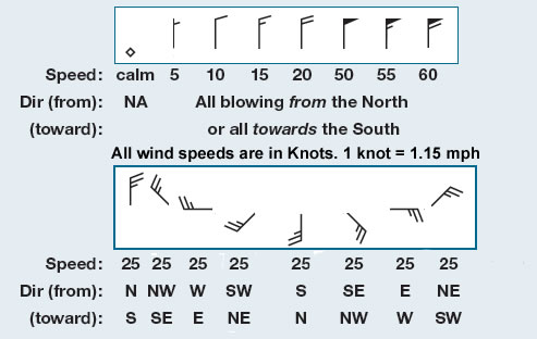
Wind Barbs |
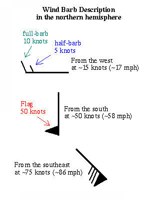 |
Wind barbs point in the direction
"from" which the wind is blowing.
Each short barb represents 5
knots, each long barb 10 knots. A long barb and a short barb is 15
knots, simply by adding the value of each barb together (10 knots +
5 knots = 15 knots). If only a station circle is plotted, the winds
are calm.
|
|
1 knot = 1 nautical mile per hour = 6076 feet per
hour = 1.15078 mph
1 mph = 1 mile per hour = 5280 feet per hour = 0.86898 knots per hour
Convert from one speed to another
Type a value in one box and click here
to see the results
|


