 Weather Center |
|
|
|
|
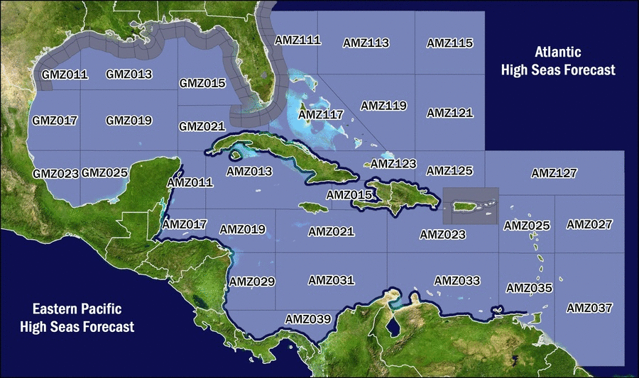
Click on a zone to display the forecast for that area.
X
AMZ011 - Caribbean N of 18N W of 85W including Yucatan BasinExpires:202204060315;;695352 FZNT23 KNHC 051514 OFFNT3 Offshore Waters Forecast for the SW and Tropical N Atlantic and Caribbean Sea NWS National Hurricane Center Miami, FL 1114 AM EDT Tue Apr 5 2022 Offshore Waters Forecast for the Tropical N Atlantic from 07N to 22N between 55W and 64W, the SW N Atlantic S of 31N W of 65W including Bahamas, and the Caribbean Sea. Seas given as significant wave height, which is the average height of the highest 1/3 of the waves. Individual waves may be more than twice the significant wave height. AMZ011-060315- Caribbean N of 18N W of 85W including Yucatan Basin- 1114 AM EDT Tue Apr 5 2022 .TODAY...SE winds 15 to 20 kt. Seas 5 to 7 ft. .TONIGHT...SE winds 15 to 20 kt. Seas 5 to 7 ft. .WED...SE winds 20 kt. Seas 6 to 8 ft. .WED NIGHT...SE winds 15 to 20 kt. Seas 4 to 6 ft. .THU...SE winds 15 to 20 kt. Seas 4 to 6 ft. .THU NIGHT...E to SE winds 10 to 15 kt. Seas 3 to 5 ft. .FRI...NE winds 15 to 20 kt. Seas 3 to 5 ft. .FRI NIGHT...NE winds 15 to 20 kt. Seas 4 to 6 ft. .SAT...NE winds 15 to 20 kt. Seas 4 to 6 ft. .SAT NIGHT...NE winds 15 to 20 kt. Seas 5 to 7 ft. $$
X
AMZ013 - Caribbean N of 18N between 76W and 85W including Cayman BasinExpires:202204060315;;695353 FZNT23 KNHC 051514 OFFNT3 Offshore Waters Forecast for the SW and Tropical N Atlantic and Caribbean Sea NWS National Hurricane Center Miami, FL 1114 AM EDT Tue Apr 5 2022 Offshore Waters Forecast for the Tropical N Atlantic from 07N to 22N between 55W and 64W, the SW N Atlantic S of 31N W of 65W including Bahamas, and the Caribbean Sea. Seas given as significant wave height, which is the average height of the highest 1/3 of the waves. Individual waves may be more than twice the significant wave height. AMZ013-060315- Caribbean N of 18N between 76W and 85W including Cayman Basin- 1114 AM EDT Tue Apr 5 2022 .TODAY...E to SE winds 15 to 20 kt. Seas 3 to 5 ft. .TONIGHT...SE winds 15 to 20 kt. Seas 3 to 5 ft. .WED...SE winds 10 to 15 kt. Seas 3 to 5 ft. .WED NIGHT...SE winds 10 to 15 kt. Seas 3 to 5 ft. .THU...SE winds 10 to 15 kt. Seas 2 to 4 ft. .THU NIGHT...SE winds 10 kt. Seas 2 to 4 ft. .FRI...NE winds 10 kt. Seas 2 to 4 ft. .FRI NIGHT...N to NE winds 15 to 20 kt. Seas 2 to 4 ft. .SAT...NE winds 15 to 20 kt. Seas 2 to 4 ft. .SAT NIGHT...N to NE winds 15 to 20 kt. Seas 2 to 4 ft. $$
X
AMZ015 - Caribbean Approaches to the Windward PassageExpires:202204060315;;695354 FZNT23 KNHC 051514 OFFNT3 Offshore Waters Forecast for the SW and Tropical N Atlantic and Caribbean Sea NWS National Hurricane Center Miami, FL 1114 AM EDT Tue Apr 5 2022 Offshore Waters Forecast for the Tropical N Atlantic from 07N to 22N between 55W and 64W, the SW N Atlantic S of 31N W of 65W including Bahamas, and the Caribbean Sea. Seas given as significant wave height, which is the average height of the highest 1/3 of the waves. Individual waves may be more than twice the significant wave height. AMZ015-060315- Caribbean Approaches to the Windward Passage- 1114 AM EDT Tue Apr 5 2022 .TODAY...E to SE winds 10 kt. Seas 2 to 4 ft. .TONIGHT...E winds 10 to 15 kt. Seas 3 to 5 ft. .WED...E to SE winds 10 to 15 kt. Seas 3 to 5 ft. .WED NIGHT...E to SE winds 10 to 15 kt. Seas 3 to 5 ft. .THU...E to SE winds 10 to 15 kt. Seas 2 to 4 ft. .THU NIGHT...S to SW winds 10 to 15 kt, shifting to E to SE late. Seas 2 to 4 ft. .FRI...NE to E winds 10 kt, shifting to S to SW in the afternoon. Seas 2 to 4 ft. .FRI NIGHT...SE to S winds 10 kt, shifting to NE to E late. Seas 3 ft or less. .SAT...E winds 10 kt, shifting to SW to W in the afternoon. Seas 3 ft or less. .SAT NIGHT...N to NE winds 10 kt. Seas 3 ft or less. $$
X
AMZ017 - Gulf of HondurasExpires:202204060315;;695355 FZNT23 KNHC 051514 OFFNT3 Offshore Waters Forecast for the SW and Tropical N Atlantic and Caribbean Sea NWS National Hurricane Center Miami, FL 1114 AM EDT Tue Apr 5 2022 Offshore Waters Forecast for the Tropical N Atlantic from 07N to 22N between 55W and 64W, the SW N Atlantic S of 31N W of 65W including Bahamas, and the Caribbean Sea. Seas given as significant wave height, which is the average height of the highest 1/3 of the waves. Individual waves may be more than twice the significant wave height. AMZ017-060315- Gulf of Honduras- 1114 AM EDT Tue Apr 5 2022 .TODAY...S of 17N W of 87W, S to SW winds 10 to 15 kt, shifting to E to SE in the afternoon. Elsewhere, E to SE winds 20 to 25 kt. Seas 5 to 7 ft in E swell. .TONIGHT...E winds 15 to 20 kt S of 17N W of 87W, and E to SE 20 to 25 kt elsewhere. Seas 5 to 7 ft in E swell. .WED...S of 17N W of 87W, S winds 10 to 15 kt in the morning, becoming variable less than 5 kt. Elsewhere, E to SE winds 20 to 25 kt. Seas 6 to 8 ft in E swell. .WED NIGHT...E winds 15 to 20 kt S of 17N W of 87W, and E to SE 20 to 25 kt elsewhere. Seas 5 to 7 ft in E swell. .THU...E to SE winds 20 to 25 kt, diminishing to 10 to 15 kt in the afternoon. Seas 4 to 6 ft. .THU NIGHT...E winds 15 to 20 kt. Seas 3 to 5 ft. .FRI...NE to E winds 10 to 15 kt. Seas 2 to 4 ft. .FRI NIGHT...NE winds 15 kt. Seas 2 to 4 ft. .SAT...NE winds 15 to 20 kt. Seas 2 to 4 ft. .SAT NIGHT...NE winds 15 to 20 kt. Seas 4 to 6 ft. $$
X
AMZ019 - Caribbean from 15N to 18N between 80W and 85WExpires:202204060315;;695356 FZNT23 KNHC 051514 OFFNT3 Offshore Waters Forecast for the SW and Tropical N Atlantic and Caribbean Sea NWS National Hurricane Center Miami, FL 1114 AM EDT Tue Apr 5 2022 Offshore Waters Forecast for the Tropical N Atlantic from 07N to 22N between 55W and 64W, the SW N Atlantic S of 31N W of 65W including Bahamas, and the Caribbean Sea. Seas given as significant wave height, which is the average height of the highest 1/3 of the waves. Individual waves may be more than twice the significant wave height. AMZ019-060315- Caribbean from 15N to 18N between 80W and 85W- 1114 AM EDT Tue Apr 5 2022 .TODAY...E to SE winds 15 to 20 kt. Seas 3 to 5 ft. .TONIGHT...E to SE winds 15 to 20 kt. Seas 4 to 6 ft. .WED...E to SE winds 15 to 20 kt. Seas 3 to 5 ft. .WED NIGHT...E to SE winds 15 to 20 kt. Seas 4 to 6 ft. .THU...E to SE winds 15 to 20 kt. Seas 2 to 4 ft. .THU NIGHT...E winds 15 to 20 kt. Seas 2 to 4 ft. .FRI...NE to E winds 10 to 15 kt. Seas 2 to 4 ft. .FRI NIGHT...NE winds 10 to 15 kt. Seas 2 to 4 ft. .SAT...NE winds 10 to 15 kt. Seas 2 to 4 ft. .SAT NIGHT...NE winds 15 to 20 kt. Seas 2 to 4 ft. $$
X
AMZ021 - Caribbean from 15N to 18N between 72W and 80WExpires:202204060315;;695357 FZNT23 KNHC 051514 OFFNT3 Offshore Waters Forecast for the SW and Tropical N Atlantic and Caribbean Sea NWS National Hurricane Center Miami, FL 1114 AM EDT Tue Apr 5 2022 Offshore Waters Forecast for the Tropical N Atlantic from 07N to 22N between 55W and 64W, the SW N Atlantic S of 31N W of 65W including Bahamas, and the Caribbean Sea. Seas given as significant wave height, which is the average height of the highest 1/3 of the waves. Individual waves may be more than twice the significant wave height. AMZ021-060315- Caribbean from 15N to 18N between 72W and 80W- 1114 AM EDT Tue Apr 5 2022 .TODAY...E winds 15 to 20 kt. Seas 4 to 6 ft. .TONIGHT...E winds 15 to 20 kt. Seas 4 to 6 ft. .WED...E winds 15 to 20 kt. Seas 5 to 7 ft. .WED NIGHT...E winds 15 to 20 kt. Seas 4 to 6 ft. .THU...E winds 15 to 20 kt. Seas 3 to 5 ft. .THU NIGHT...E winds 10 to 15 kt. Seas 3 to 5 ft. .FRI...E winds 10 to 15 kt. Seas 3 to 5 ft. .FRI NIGHT...E winds 10 to 15 kt. Seas 3 to 5 ft. .SAT...E winds 10 to 15 kt. Seas 3 to 5 ft. .SAT NIGHT...NE to E winds 10 to 15 kt. Seas 2 to 4 ft. $$
X
AMZ023 - Caribbean N of 15N between 64W and 72WExpires:202204060315;;695358 FZNT23 KNHC 051514 OFFNT3 Offshore Waters Forecast for the SW and Tropical N Atlantic and Caribbean Sea NWS National Hurricane Center Miami, FL 1114 AM EDT Tue Apr 5 2022 Offshore Waters Forecast for the Tropical N Atlantic from 07N to 22N between 55W and 64W, the SW N Atlantic S of 31N W of 65W including Bahamas, and the Caribbean Sea. Seas given as significant wave height, which is the average height of the highest 1/3 of the waves. Individual waves may be more than twice the significant wave height. AMZ023-060315- Caribbean N of 15N between 64W and 72W- 1114 AM EDT Tue Apr 5 2022 .TODAY...E winds 15 to 20 kt. Seas 4 to 6 ft. .TONIGHT...E winds 15 to 20 kt. Seas 4 to 6 ft. .WED...E winds 15 to 20 kt. Seas 4 to 6 ft. .WED NIGHT...E winds 15 to 20 kt. Seas 4 to 6 ft. .THU...E winds 15 to 20 kt. Seas 4 to 6 ft. .THU NIGHT...E winds 15 to 20 kt. Seas 3 to 5 ft. .FRI...E winds 15 kt. Seas 3 to 5 ft. .FRI NIGHT...E winds 15 to 20 kt. Seas 4 to 6 ft. .SAT...E winds 15 to 20 kt. Seas 4 to 6 ft. .SAT NIGHT...E winds 15 kt. Seas 4 to 6 ft. $$
X
AMZ025 - Offshore Waters Leeward IslandsExpires:202204060315;;695359 FZNT23 KNHC 051514 OFFNT3 Offshore Waters Forecast for the SW and Tropical N Atlantic and Caribbean Sea NWS National Hurricane Center Miami, FL 1114 AM EDT Tue Apr 5 2022 Offshore Waters Forecast for the Tropical N Atlantic from 07N to 22N between 55W and 64W, the SW N Atlantic S of 31N W of 65W including Bahamas, and the Caribbean Sea. Seas given as significant wave height, which is the average height of the highest 1/3 of the waves. Individual waves may be more than twice the significant wave height. AMZ025-060315- Offshore Waters Leeward Islands- 1114 AM EDT Tue Apr 5 2022 .TODAY...E to SE winds 15 to 20 kt. Seas 4 to 6 ft. .TONIGHT...E winds 15 to 20 kt. Seas 4 to 6 ft. .WED...E winds 15 to 20 kt. Seas 4 to 6 ft. .WED NIGHT...E winds 10 to 15 kt. Seas 4 to 6 ft. .THU...E winds 10 to 15 kt. Seas 3 to 5 ft. .THU NIGHT...E winds 15 to 20 kt. Seas 3 to 5 ft. .FRI...E winds 15 to 20 kt. Seas 3 to 5 ft. .FRI NIGHT...E winds 15 to 20 kt. Seas 3 to 5 ft. .SAT...E winds 15 kt. Seas 4 to 6 ft. .SAT NIGHT...E winds 15 to 20 kt. Seas 3 to 5 ft. $$
X
AMZ027 - Tropical N Atlantic from 15N to 19N between 55W and 60WExpires:202204060315;;695360 FZNT23 KNHC 051514 OFFNT3 Offshore Waters Forecast for the SW and Tropical N Atlantic and Caribbean Sea NWS National Hurricane Center Miami, FL 1114 AM EDT Tue Apr 5 2022 Offshore Waters Forecast for the Tropical N Atlantic from 07N to 22N between 55W and 64W, the SW N Atlantic S of 31N W of 65W including Bahamas, and the Caribbean Sea. Seas given as significant wave height, which is the average height of the highest 1/3 of the waves. Individual waves may be more than twice the significant wave height. AMZ027-060315- Tropical N Atlantic from 15N to 19N between 55W and 60W- 1114 AM EDT Tue Apr 5 2022 .TODAY...E winds 15 to 20 kt. Seas 5 to 7 ft. .TONIGHT...E winds 15 kt. Seas 4 to 6 ft. .WED...E winds 15 to 20 kt. Seas 5 to 7 ft. .WED NIGHT...E winds 15 kt. Seas 5 to 7 ft in E swell. Scattered showers. .THU...E winds 15 to 20 kt. Seas 5 to 7 ft. .THU NIGHT...E winds 15 kt. Seas 4 to 6 ft. .FRI...E winds 15 kt. Seas 4 to 6 ft. .FRI NIGHT...E winds 15 to 20 kt. Seas 5 to 7 ft. .SAT...E winds 15 kt. Seas 5 to 7 ft. .SAT NIGHT...E winds 15 to 20 kt. Seas 5 to 7 ft. $$
X
AMZ029 - W Central Caribbean from 11N to 15N W of 80WExpires:202204060315;;695361 FZNT23 KNHC 051514 OFFNT3 Offshore Waters Forecast for the SW and Tropical N Atlantic and Caribbean Sea NWS National Hurricane Center Miami, FL 1114 AM EDT Tue Apr 5 2022 Offshore Waters Forecast for the Tropical N Atlantic from 07N to 22N between 55W and 64W, the SW N Atlantic S of 31N W of 65W including Bahamas, and the Caribbean Sea. Seas given as significant wave height, which is the average height of the highest 1/3 of the waves. Individual waves may be more than twice the significant wave height. AMZ029-060315- W Central Caribbean from 11N to 15N W of 80W- 1114 AM EDT Tue Apr 5 2022 .TODAY...E winds 10 to 15 kt. Seas 3 to 5 ft. .TONIGHT...E winds 10 to 15 kt. Seas 3 to 5 ft. .WED...E winds 10 to 15 kt. Seas 4 to 6 ft. .WED NIGHT...E winds 10 to 15 kt. Seas 4 to 6 ft. .THU...E winds 10 to 15 kt. Seas 3 to 5 ft. .THU NIGHT...NE to E winds 10 to 15 kt. Seas 3 to 5 ft. .FRI...NE to E winds 10 to 15 kt. Seas 3 to 5 ft. .FRI NIGHT...NE winds 15 kt. Seas 3 to 5 ft. .SAT...NE winds 15 to 20 kt. Seas 3 to 5 ft. .SAT NIGHT...NE winds 15 kt. Seas 3 to 5 ft. $$
X
AMZ031 - Caribbean from 11N to 15N between 72W and 80W including Colombia BasinExpires:202204060315;;695362 FZNT23 KNHC 051514 OFFNT3 Offshore Waters Forecast for the SW and Tropical N Atlantic and Caribbean Sea NWS National Hurricane Center Miami, FL 1114 AM EDT Tue Apr 5 2022 Offshore Waters Forecast for the Tropical N Atlantic from 07N to 22N between 55W and 64W, the SW N Atlantic S of 31N W of 65W including Bahamas, and the Caribbean Sea. Seas given as significant wave height, which is the average height of the highest 1/3 of the waves. Individual waves may be more than twice the significant wave height. AMZ031-060315- Caribbean from 11N to 15N between 72W and 80W including Colombia Basin- 1114 AM EDT Tue Apr 5 2022 .TODAY...E winds 15 to 20 kt. Seas 5 to 7 ft. .TONIGHT...NE to E winds 20 to 25 kt within 90 nm of coast of Colombia, and NE to E 15 to 20 kt elsewhere. Seas 5 to 7 ft. .WED...NE to E winds 15 to 20 kt. Seas 6 to 8 ft in E swell. .WED NIGHT...NE to E winds 20 to 25 kt within 90 nm of coast of Colombia, and NE to E 15 to 20 kt elsewhere. Seas 6 to 8 ft. .THU...NE to E winds 15 to 20 kt. Seas 5 to 7 ft. .THU NIGHT...NE to E winds 15 to 20 kt. Seas 5 to 7 ft. .FRI...NE to E winds 15 to 20 kt. Seas 5 to 7 ft. .FRI NIGHT...NE to E winds 15 to 20 kt. Seas 4 to 6 ft. .SAT...NE to E winds 15 to 20 kt. Seas 4 to 6 ft. .SAT NIGHT...NE to E winds 15 to 20 kt. Seas 5 to 7 ft. $$
X
AMZ033 - Caribbean S of 15N between 64W and 72W including Venezuela BasinExpires:202204060315;;695363 FZNT23 KNHC 051514 OFFNT3 Offshore Waters Forecast for the SW and Tropical N Atlantic and Caribbean Sea NWS National Hurricane Center Miami, FL 1114 AM EDT Tue Apr 5 2022 Offshore Waters Forecast for the Tropical N Atlantic from 07N to 22N between 55W and 64W, the SW N Atlantic S of 31N W of 65W including Bahamas, and the Caribbean Sea. Seas given as significant wave height, which is the average height of the highest 1/3 of the waves. Individual waves may be more than twice the significant wave height. AMZ033-060315- Caribbean S of 15N between 64W and 72W including Venezuela Basin- 1114 AM EDT Tue Apr 5 2022 .TODAY...E winds 15 to 20 kt. Seas 4 to 6 ft. .TONIGHT...NE to E winds 20 to 25 kt Gulf of Venezuela, and E 15 to 20 kt elsewhere. Seas 4 to 6 ft. .WED...E winds 15 to 20 kt. Seas 4 to 6 ft. .WED NIGHT...NE to E winds 20 to 25 kt Gulf of Venezuela, and E 15 to 20 kt elsewhere. Seas 4 to 6 ft. .THU...E winds 15 to 20 kt. Seas 4 to 6 ft. .THU NIGHT...NE to E winds 15 to 20 kt. Seas 3 to 5 ft. .FRI...E winds 15 to 20 kt. Seas 3 to 5 ft. .FRI NIGHT...E winds 15 to 20 kt. Seas 3 to 5 ft. .SAT...E winds 15 to 20 kt. Seas 4 to 6 ft. .SAT NIGHT...E winds 15 to 20 kt. Seas 4 to 6 ft. $$
X
AMZ035 - Offshore Waters Windward Islands including Trindad and TobagoExpires:202204060315;;695364 FZNT23 KNHC 051514 OFFNT3 Offshore Waters Forecast for the SW and Tropical N Atlantic and Caribbean Sea NWS National Hurricane Center Miami, FL 1114 AM EDT Tue Apr 5 2022 Offshore Waters Forecast for the Tropical N Atlantic from 07N to 22N between 55W and 64W, the SW N Atlantic S of 31N W of 65W including Bahamas, and the Caribbean Sea. Seas given as significant wave height, which is the average height of the highest 1/3 of the waves. Individual waves may be more than twice the significant wave height. AMZ035-060315- Offshore Waters Windward Islands including Trinidad and Tobago- 1114 AM EDT Tue Apr 5 2022 .TODAY...E winds 15 kt. Seas 4 to 6 ft. .TONIGHT...E winds 15 to 20 kt. Seas 4 to 6 ft. .WED...E winds 15 to 20 kt. Seas 4 to 6 ft. .WED NIGHT...E winds 15 to 20 kt. Seas 4 to 6 ft. .THU...E winds 15 to 20 kt. Seas 3 to 5 ft. .THU NIGHT...E winds 15 kt. Seas 3 to 5 ft. .FRI...E winds 15 kt. Seas 3 to 5 ft. .FRI NIGHT...E winds 15 to 20 kt. Seas 3 to 5 ft. .SAT...E winds 15 to 20 kt. Seas 3 to 5 ft. .SAT NIGHT...E winds 15 to 20 kt. Seas 4 to 6 ft. $$
X
AMZ037 - Tropical N Atlantic from 07N to 15N between 55W and 60WExpires:202204060315;;695365 FZNT23 KNHC 051514 OFFNT3 Offshore Waters Forecast for the SW and Tropical N Atlantic and Caribbean Sea NWS National Hurricane Center Miami, FL 1114 AM EDT Tue Apr 5 2022 Offshore Waters Forecast for the Tropical N Atlantic from 07N to 22N between 55W and 64W, the SW N Atlantic S of 31N W of 65W including Bahamas, and the Caribbean Sea. Seas given as significant wave height, which is the average height of the highest 1/3 of the waves. Individual waves may be more than twice the significant wave height. AMZ037-060315- Tropical N Atlantic from 07N to 15N between 55W and 60W- 1114 AM EDT Tue Apr 5 2022 .TODAY...E winds 15 to 20 kt. Seas 5 to 7 ft. .TONIGHT...NE to E winds 15 to 20 kt. Seas 5 to 7 ft. .WED...E winds 15 to 20 kt. Seas 5 to 7 ft. .WED NIGHT...E winds 15 to 20 kt. Seas 5 to 7 ft. .THU...E winds 15 kt. Seas 5 to 7 ft. .THU NIGHT...E winds 15 to 20 kt. Seas 5 to 7 ft. .FRI...E winds 15 kt. Seas 5 to 7 ft. .FRI NIGHT...E winds 15 to 20 kt. Seas 5 to 7 ft. .SAT...E winds 15 to 20 kt. Seas 5 to 7 ft. .SAT NIGHT...E winds 15 to 20 kt. Seas 5 to 7 ft. $$
X
AMZ039 - SW Caribbean S of 11N including Approaches to Panama CanalExpires:202204060315;;695366 FZNT23 KNHC 051514 OFFNT3 Offshore Waters Forecast for the SW and Tropical N Atlantic and Caribbean Sea NWS National Hurricane Center Miami, FL 1114 AM EDT Tue Apr 5 2022 Offshore Waters Forecast for the Tropical N Atlantic from 07N to 22N between 55W and 64W, the SW N Atlantic S of 31N W of 65W including Bahamas, and the Caribbean Sea. Seas given as significant wave height, which is the average height of the highest 1/3 of the waves. Individual waves may be more than twice the significant wave height. AMZ039-060315- SW Caribbean S of 11N including Approaches to Panama Canal- 1114 AM EDT Tue Apr 5 2022 .TODAY...NE to E winds 10 to 15 kt. Seas 3 to 5 ft. Scattered showers. .TONIGHT...NE winds 10 to 15 kt. Seas 4 to 6 ft. .WED...NE winds 10 to 15 kt. Seas 5 to 7 ft in NE swell. .WED NIGHT...NE winds 10 to 15 kt. Seas 5 to 7 ft in NE swell. Scattered showers. .THU...NE winds 10 to 15 kt. Seas 4 to 6 ft. .THU NIGHT...N to NE winds 10 to 15 kt. Seas 3 to 5 ft. .FRI...NE winds 15 to 20 kt. Seas 3 to 5 ft. .FRI NIGHT...NE winds 15 to 20 kt. Seas 3 to 5 ft. .SAT...NE winds 15 to 20 kt. Seas 4 to 6 ft. .SAT NIGHT...N to NE winds 15 to 20 kt. Seas 4 to 6 ft. $$
X
AMZ111 - Atlantic from 27N to 31N W of 77WExpires:202204060315;;695368 FZNT23 KNHC 051514 OFFNT3 Offshore Waters Forecast for the SW and Tropical N Atlantic and Caribbean Sea NWS National Hurricane Center Miami, FL 1114 AM EDT Tue Apr 5 2022 Offshore Waters Forecast for the Tropical N Atlantic from 07N to 22N between 55W and 64W, the SW N Atlantic S of 31N W of 65W including Bahamas, and the Caribbean Sea. Seas given as significant wave height, which is the average height of the highest 1/3 of the waves. Individual waves may be more than twice the significant wave height. AMZ111-060315- Atlantic from 27N to 31N W of 77W- 1114 AM EDT Tue Apr 5 2022 .TODAY...SE to S winds 15 to 20 kt. Seas 3 to 5 ft. .TONIGHT...S winds 20 to 25 kt. Seas 5 to 7 ft. Scattered showers. .WED...S to SW winds 15 to 20 kt. Seas 5 to 7 ft. .WED NIGHT...S winds 20 to 25 kt. Seas 4 to 6 ft. Scattered showers. .THU...S to SW winds 20 to 25 kt. Seas 4 to 6 ft. .THU NIGHT...SW winds 15 to 20 kt, shifting to W to NW late. Seas 4 to 6 ft. .FRI...W winds 15 to 20 kt. Seas 3 to 5 ft. .FRI NIGHT...W winds 20 to 25 kt. Seas 4 to 6 ft. .SAT...W to NW winds 20 to 25 kt. Seas 5 to 7 ft. .SAT NIGHT...W to NW winds 20 to 25 kt. Seas 6 to 8 ft. $$
X
AMZ113 - Atlantic from 27N to 31N between 70W and 77WExpires:202204060315;;695369 FZNT23 KNHC 051514 OFFNT3 Offshore Waters Forecast for the SW and Tropical N Atlantic and Caribbean Sea NWS National Hurricane Center Miami, FL 1114 AM EDT Tue Apr 5 2022 Offshore Waters Forecast for the Tropical N Atlantic from 07N to 22N between 55W and 64W, the SW N Atlantic S of 31N W of 65W including Bahamas, and the Caribbean Sea. Seas given as significant wave height, which is the average height of the highest 1/3 of the waves. Individual waves may be more than twice the significant wave height. AMZ113-060315- Atlantic from 27N to 31N between 70W and 77W- 1114 AM EDT Tue Apr 5 2022 .TODAY...E to SE winds 10 to 15 kt. Seas 3 to 5 ft. .TONIGHT...SE to S winds 15 to 20 kt. Seas 3 to 5 ft. .WED...S to SW winds 15 to 20 kt. Seas 4 to 6 ft. .WED NIGHT...S to SW winds 15 to 20 kt. Seas 3 to 5 ft. .THU...S to SW winds 15 to 20 kt. Seas 3 to 5 ft. .THU NIGHT...S to SW winds 15 to 20 kt. Seas 4 to 6 ft. .FRI...SW winds 15 to 20 kt. Seas 5 to 7 ft. .FRI NIGHT...SW to W winds 10 to 15 kt. Seas 5 to 7 ft in SW swell. .SAT...W winds 20 to 25 kt. Seas 5 to 7 ft. .SAT NIGHT...W to NW winds 20 to 25 kt. Seas 6 to 9 ft in W to NW swell. $$
X
AMZ115 - Atlantic from 27N to 31N between 65W and 70WExpires:202204060315;;695370 FZNT23 KNHC 051514 OFFNT3 Offshore Waters Forecast for the SW and Tropical N Atlantic and Caribbean Sea NWS National Hurricane Center Miami, FL 1114 AM EDT Tue Apr 5 2022 Offshore Waters Forecast for the Tropical N Atlantic from 07N to 22N between 55W and 64W, the SW N Atlantic S of 31N W of 65W including Bahamas, and the Caribbean Sea. Seas given as significant wave height, which is the average height of the highest 1/3 of the waves. Individual waves may be more than twice the significant wave height. AMZ115-060315- Atlantic from 27N to 31N between 65W and 70W- 1114 AM EDT Tue Apr 5 2022 .TODAY...NE to E winds 10 to 15 kt. Seas 4 to 6 ft. .TONIGHT...E to SE winds 10 to 15 kt. Seas 4 to 6 ft. .WED...S winds 10 to 15 kt. Seas 3 to 5 ft. .WED NIGHT...SW winds 10 kt. Seas 2 to 4 ft. .THU...S to SW winds 10 to 15 kt. Seas 2 to 4 ft. .THU NIGHT...S winds 10 to 15 kt. Seas 2 to 4 ft. .FRI...S winds 15 to 20 kt. Seas 3 to 5 ft. .FRI NIGHT...S winds 15 to 20 kt. Seas 4 to 6 ft. .SAT...S to SW winds 15 to 20 kt. Seas 4 to 6 ft. .SAT NIGHT...SW to W winds 15 to 20 kt. Seas 5 to 7 ft. $$
X
AMZ117 - Bahamas including Cay Sal BankExpires:202204060315;;695371 FZNT23 KNHC 051514 OFFNT3 Offshore Waters Forecast for the SW and Tropical N Atlantic and Caribbean Sea NWS National Hurricane Center Miami, FL 1114 AM EDT Tue Apr 5 2022 Offshore Waters Forecast for the Tropical N Atlantic from 07N to 22N between 55W and 64W, the SW N Atlantic S of 31N W of 65W including Bahamas, and the Caribbean Sea. Seas given as significant wave height, which is the average height of the highest 1/3 of the waves. Individual waves may be more than twice the significant wave height. AMZ117-060315- Bahamas including Cay Sal Bank- 1114 AM EDT Tue Apr 5 2022 .TODAY...SE winds 10 to 15 kt. Seas 2 to 4 ft. .TONIGHT...SE winds 10 to 15 kt. Seas 2 to 4 ft. .WED...SE winds 10 to 15 kt. Seas 2 to 4 ft. .WED NIGHT...SE winds 10 to 15 kt. Seas 2 to 4 ft. .THU...SE to S winds 10 to 15 kt. Seas 3 ft or less. .THU NIGHT...SE to S winds 10 to 15 kt. Seas 3 ft or less. .FRI...S winds 10 to 15 kt, shifting to W to NW in the afternoon. Seas 3 ft or less. .FRI NIGHT...N winds 10 to 15 kt. Seas 3 ft or less. .SAT...NW to N winds 10 to 15 kt. Seas 3 ft or less. .SAT NIGHT...N winds 10 to 15 kt. Seas 2 to 4 ft. $$
X
AMZ119 - Atlantic from 22N to 27N E of Bahamas to 70WExpires:202204060315;;695372 FZNT23 KNHC 051514 OFFNT3 Offshore Waters Forecast for the SW and Tropical N Atlantic and Caribbean Sea NWS National Hurricane Center Miami, FL 1114 AM EDT Tue Apr 5 2022 Offshore Waters Forecast for the Tropical N Atlantic from 07N to 22N between 55W and 64W, the SW N Atlantic S of 31N W of 65W including Bahamas, and the Caribbean Sea. Seas given as significant wave height, which is the average height of the highest 1/3 of the waves. Individual waves may be more than twice the significant wave height. AMZ119-060315- Atlantic from 22N to 27N E of Bahamas to 70W- 1114 AM EDT Tue Apr 5 2022 .TODAY...E to SE winds 10 to 15 kt. Seas 2 to 4 ft. .TONIGHT...E to SE winds 10 to 15 kt. Seas 2 to 4 ft. .WED...SE to S winds 10 to 15 kt. Seas 2 to 4 ft. .WED NIGHT...SE winds 10 to 15 kt. Seas 3 to 5 ft. .THU...SE to S winds 10 to 15 kt. Seas 2 to 4 ft. .THU NIGHT...SE to S winds 10 to 15 kt. Seas 2 to 4 ft. .FRI...S winds 10 to 15 kt. Seas 3 to 5 ft. .FRI NIGHT...SE to S winds 10 to 15 kt. Seas 3 to 5 ft. .SAT...S to SW winds 10 to 15 kt. Seas 3 to 5 ft. .SAT NIGHT...NW winds 10 to 15 kt. Seas 3 to 5 ft. $$
X
AMZ121 - Atlantic from 22N to 27N between 65W and 70WExpires:202204060315;;695373 FZNT23 KNHC 051514 OFFNT3 Offshore Waters Forecast for the SW and Tropical N Atlantic and Caribbean Sea NWS National Hurricane Center Miami, FL 1114 AM EDT Tue Apr 5 2022 Offshore Waters Forecast for the Tropical N Atlantic from 07N to 22N between 55W and 64W, the SW N Atlantic S of 31N W of 65W including Bahamas, and the Caribbean Sea. Seas given as significant wave height, which is the average height of the highest 1/3 of the waves. Individual waves may be more than twice the significant wave height. AMZ121-060315- Atlantic from 22N to 27N between 65W and 70W- 1114 AM EDT Tue Apr 5 2022 .TODAY...SE winds 10 kt. Seas 2 to 4 ft. .TONIGHT...SE winds 10 kt. Seas 3 to 5 ft. .WED...SE winds 10 to 15 kt. Seas 3 to 5 ft. .WED NIGHT...SE winds 10 to 15 kt. Seas 3 to 5 ft. .THU...SE winds 10 to 15 kt. Seas 3 to 5 ft. .THU NIGHT...SE winds 10 to 15 kt. Seas 3 to 5 ft. .FRI...SE winds 10 to 15 kt. Seas 3 to 5 ft. .FRI NIGHT...SE winds 10 to 15 kt. Seas 3 to 5 ft. .SAT...SE to S winds 10 to 15 kt. Seas 3 to 5 ft. .SAT NIGHT...S winds 10 to 15 kt. Seas 3 to 5 ft. $$
X
AMZ123 - Atlantic S of 22N W of 70W including Approaches to the Windward PassageExpires:202204060315;;695374 FZNT23 KNHC 051514 OFFNT3 Offshore Waters Forecast for the SW and Tropical N Atlantic and Caribbean Sea NWS National Hurricane Center Miami, FL 1114 AM EDT Tue Apr 5 2022 Offshore Waters Forecast for the Tropical N Atlantic from 07N to 22N between 55W and 64W, the SW N Atlantic S of 31N W of 65W including Bahamas, and the Caribbean Sea. Seas given as significant wave height, which is the average height of the highest 1/3 of the waves. Individual waves may be more than twice the significant wave height. AMZ123-060315- Atlantic S of 22N W of 70W including Approaches to the Windward Passage- 1114 AM EDT Tue Apr 5 2022 .TODAY...E winds 10 to 15 kt. Seas 2 to 4 ft. .TONIGHT...E winds 15 to 20 kt. Seas 3 to 5 ft. .WED...E to SE winds 10 to 15 kt. Seas 2 to 4 ft. .WED NIGHT...E to SE winds 15 to 20 kt. Seas 4 to 6 ft. .THU...E to SE winds 15 to 20 kt. Seas 2 to 4 ft. .THU NIGHT...E to SE winds 15 to 20 kt. Seas 3 to 5 ft. .FRI...E to SE winds 10 to 15 kt. Seas 2 to 4 ft. .FRI NIGHT...E to SE winds 15 to 20 kt. Seas 2 to 4 ft. .SAT...E winds 10 to 15 kt. Seas 2 to 4 ft. .SAT NIGHT...NE to E winds 10 to 15 kt. Seas 2 to 4 ft. $$
X
AMZ125 - Atlantic S of 22N between 65W and 70W including Puerto Rico TrenchExpires:202204060315;;695375 FZNT23 KNHC 051514 OFFNT3 Offshore Waters Forecast for the SW and Tropical N Atlantic and Caribbean Sea NWS National Hurricane Center Miami, FL 1114 AM EDT Tue Apr 5 2022 Offshore Waters Forecast for the Tropical N Atlantic from 07N to 22N between 55W and 64W, the SW N Atlantic S of 31N W of 65W including Bahamas, and the Caribbean Sea. Seas given as significant wave height, which is the average height of the highest 1/3 of the waves. Individual waves may be more than twice the significant wave height. AMZ125-060315- Atlantic S of 22N between 65W and 70W including Puerto Rico Trench- 1114 AM EDT Tue Apr 5 2022 .TODAY...E to SE winds 10 to 15 kt. Seas 3 to 5 ft. .TONIGHT...E to SE winds 10 to 15 kt. Seas 3 to 5 ft. .WED...E to SE winds 15 kt. Seas 3 to 5 ft. .WED NIGHT...E to SE winds 15 to 20 kt. Seas 4 to 6 ft. .THU...E to SE winds 10 to 15 kt. Seas 4 to 6 ft. .THU NIGHT...E winds 15 kt. Seas 3 to 5 ft. .FRI...E to SE winds 15 kt. Seas 3 to 5 ft. .FRI NIGHT...E to SE winds 15 to 20 kt. Seas 3 to 5 ft. .SAT...E to SE winds 15 kt. Seas 4 to 6 ft. .SAT NIGHT...E to SE winds 10 to 15 kt. Seas 4 to 6 ft. $$
X
AMZ127 - Atlantic from 19N to 22N between 55W and 65WExpires:202204060315;;695376 FZNT23 KNHC 051514 OFFNT3 Offshore Waters Forecast for the SW and Tropical N Atlantic and Caribbean Sea NWS National Hurricane Center Miami, FL 1114 AM EDT Tue Apr 5 2022 Offshore Waters Forecast for the Tropical N Atlantic from 07N to 22N between 55W and 64W, the SW N Atlantic S of 31N W of 65W including Bahamas, and the Caribbean Sea. Seas given as significant wave height, which is the average height of the highest 1/3 of the waves. Individual waves may be more than twice the significant wave height. AMZ127-060315- Atlantic from 19N to 22N between 55W and 65W- 1114 AM EDT Tue Apr 5 2022 .TODAY...E to SE winds 10 to 15 kt. Seas 4 to 6 ft. .TONIGHT...E winds 10 to 15 kt. Seas 4 to 6 ft. .WED...E winds 15 to 20 kt. Seas 4 to 6 ft. .WED NIGHT...E winds 10 to 15 kt. Seas 4 to 6 ft. .THU...E winds 10 to 15 kt. Seas 4 to 6 ft. .THU NIGHT...E winds 10 to 15 kt. Seas 4 to 6 ft. .FRI...E winds 15 kt. Seas 4 to 6 ft. .FRI NIGHT...E winds 15 to 20 kt. Seas 4 to 6 ft. .SAT...E to SE winds 15 kt. Seas 4 to 6 ft. .SAT NIGHT...E to SE winds 15 to 20 kt. Seas 4 to 6 ft. $$ Forecaster GR
X
GMZ011 - NW Gulf including Stetson BankExpires:202204060315;;695191 FZNT24 KNHC 051512 OFFNT4 Offshore Waters Forecast for the Gulf of Mexico NWS National Hurricane Center Miami, FL 1112 AM EDT Tue Apr 5 2022 Offshore Waters Forecast for the Gulf of Mexico Seas given as significant wave height, which is the average height of the highest 1/3 of the waves. Individual waves may be more than twice the significant wave height. GMZ011-060315- NW Gulf including Stetson Bank- 1112 AM EDT Tue Apr 5 2022 .TODAY...SE to S winds 10 kt. Seas 2 to 4 ft. .TONIGHT...SE to S winds 10 to 15 kt. Seas 2 to 4 ft. .WED...S to SW winds 10 to 15 kt, shifting to W in the afternoon. Seas 2 to 4 ft. .WED NIGHT...NW to N winds 10 to 15 kt, becoming N to NE 25 to 30 kt late. Seas 3 to 5 ft. .THU...N to NE winds 20 to 25 kt. Seas 6 to 8 ft. .THU NIGHT...N to NE winds 15 to 20 kt. Seas 4 to 6 ft. .FRI...N to NE winds 10 kt. Seas 2 to 4 ft. .FRI NIGHT...S winds 10 kt. Seas 3 ft or less. .SAT...SE to S winds 10 to 15 kt. Seas 3 ft or less. .SAT NIGHT...SE to S winds 15 to 20 kt. Seas 2 to 4 ft. $$
X
GMZ013 - N Central Gulf including Flower Garden Banks Marine SanctuaryExpires:202204060315;;695192 FZNT24 KNHC 051512 OFFNT4 Offshore Waters Forecast for the Gulf of Mexico NWS National Hurricane Center Miami, FL 1112 AM EDT Tue Apr 5 2022 Offshore Waters Forecast for the Gulf of Mexico Seas given as significant wave height, which is the average height of the highest 1/3 of the waves. Individual waves may be more than twice the significant wave height. GMZ013-060315- N Central Gulf including Flower Garden Banks Marine Sanctuary- 1112 AM EDT Tue Apr 5 2022 .TODAY...S winds 15 to 20 kt W of 90W, and S 20 kt elsewhere. Seas 4 to 6 ft. .TONIGHT...S winds 10 to 15 kt. Seas 4 to 6 ft. .WED...S to SW winds 15 to 20 kt. Seas 3 to 5 ft. .WED NIGHT...W of 90W, W winds 10 to 15 kt, becoming N 25 to 30 kt late. Elsewhere, SW to W winds 15 to 20 kt. Seas 3 to 5 ft. .THU...N winds 20 to 25 kt. Seas 5 to 7 ft. .THU NIGHT...NW to N winds 20 to 25 kt. Seas 4 to 6 ft. .FRI...NW to N winds 15 to 20 kt. Seas 4 to 6 ft. .FRI NIGHT...NW winds 15 to 20 kt. Seas 3 to 5 ft. .SAT...N winds 15 to 20 kt. Seas 2 to 4 ft. .SAT NIGHT...E winds 15 to 20 kt. Seas 2 to 4 ft. $$
X
GMZ015 - NE Gulf N of 25N E of 87WExpires:202204060315;;695193 FZNT24 KNHC 051512 OFFNT4 Offshore Waters Forecast for the Gulf of Mexico NWS National Hurricane Center Miami, FL 1112 AM EDT Tue Apr 5 2022 Offshore Waters Forecast for the Gulf of Mexico Seas given as significant wave height, which is the average height of the highest 1/3 of the waves. Individual waves may be more than twice the significant wave height. GMZ015-060315- NE Gulf N of 25N E of 87W- 1112 AM EDT Tue Apr 5 2022 .TODAY...S winds 15 to 20 kt. Seas 2 to 4 ft. .TONIGHT...S winds 15 to 20 kt. Seas 3 to 5 ft. .WED...S winds 15 to 20 kt. Seas 4 to 6 ft. .WED NIGHT...S to SW winds 15 to 20 kt. Seas 3 to 5 ft. .THU...W winds 15 to 20 kt. Seas 3 to 5 ft. .THU NIGHT...NW winds 20 to 25 kt. Seas 4 to 6 ft. .FRI...NW winds 15 to 20 kt. Seas 4 to 6 ft. .FRI NIGHT...NW winds 15 to 20 kt. Seas 4 to 6 ft. .SAT...NW winds 15 to 20 kt. Seas 4 to 6 ft. .SAT NIGHT...N winds 10 to 15 kt. Seas 4 to 6 ft. $$
X
GMZ017 - W Central Gulf from 22N to 26N W of 94WExpires:202204060315;;695194 FZNT24 KNHC 051512 OFFNT4 Offshore Waters Forecast for the Gulf of Mexico NWS National Hurricane Center Miami, FL 1112 AM EDT Tue Apr 5 2022 Offshore Waters Forecast for the Gulf of Mexico Seas given as significant wave height, which is the average height of the highest 1/3 of the waves. Individual waves may be more than twice the significant wave height. GMZ017-060315- W Central Gulf from 22N to 26N W of 94W- 1112 AM EDT Tue Apr 5 2022 .TODAY...SE winds 10 to 15 kt W of 96W, and SE 15 to 20 kt elsewhere. Seas 2 to 4 ft. .TONIGHT...SE to S winds 10 to 15 kt. Seas 2 to 4 ft. .WED...S winds 10 kt. Seas 2 to 4 ft. .WED NIGHT...NE winds 20 to 25 kt. Seas 2 to 4 ft. .THU...N to NE winds 20 to 25 kt. Seas 5 to 7 ft. .THU NIGHT...NE winds 15 to 20 kt. Seas 6 to 8 ft. .FRI...NE to E winds 15 to 20 kt. Seas 4 to 6 ft. .FRI NIGHT...E to SE winds 10 to 15 kt. Seas 3 to 5 ft. .SAT...SE winds 10 to 15 kt. Seas 2 to 4 ft. .SAT NIGHT...SE winds 15 to 20 kt. Seas 2 to 4 ft. $$
X
GMZ019 - W Central Gulf from 22N to 26N W of 94WExpires:202204060315;;695195 FZNT24 KNHC 051512 OFFNT4 Offshore Waters Forecast for the Gulf of Mexico NWS National Hurricane Center Miami, FL 1112 AM EDT Tue Apr 5 2022 Offshore Waters Forecast for the Gulf of Mexico Seas given as significant wave height, which is the average height of the highest 1/3 of the waves. Individual waves may be more than twice the significant wave height. GMZ019-060315- Central Gulf from 22N to 26N between 87W and 94W- 1112 AM EDT Tue Apr 5 2022 .TODAY...SE to S winds 20 to 25 kt. Seas 4 to 6 ft. .TONIGHT...SE winds 15 to 20 kt. Seas 4 to 6 ft. .WED...S winds 20 to 25 kt. Seas 4 to 6 ft. .WED NIGHT...S to SW winds 10 to 15 kt, shifting to NE to E late. Seas 3 to 5 ft. .THU...N to NE winds 20 to 25 kt. Seas 4 to 6 ft. .THU NIGHT...N to NE winds 20 to 25 kt. Seas 5 to 7 ft. .FRI...N to NE winds 20 to 25 kt. Seas 6 to 9 ft. .FRI NIGHT...N to NE winds 15 to 20 kt. Seas 4 to 6 ft. .SAT...NE winds 10 to 15 kt. Seas 3 to 5 ft. .SAT NIGHT...E winds 15 to 20 kt. Seas 2 to 4 ft. $$
X
GMZ021 - E Gulf from 22N to 25N E of 87W including Straits of FloridaExpires:202204060315;;695196 FZNT24 KNHC 051512 OFFNT4 Offshore Waters Forecast for the Gulf of Mexico NWS National Hurricane Center Miami, FL 1112 AM EDT Tue Apr 5 2022 Offshore Waters Forecast for the Gulf of Mexico Seas given as significant wave height, which is the average height of the highest 1/3 of the waves. Individual waves may be more than twice the significant wave height. GMZ021-060315- E Gulf from 22N to 25N E of 87W including Straits of Florida- 1112 AM EDT Tue Apr 5 2022 .TODAY...SE to S winds 15 to 20 kt. Seas 2 to 4 ft. .TONIGHT...SE to S winds 15 to 20 kt. Seas 3 to 5 ft. .WED...SE to S winds 15 to 20 kt. Seas 3 to 5 ft. .WED NIGHT...S winds 15 to 20 kt. Seas 2 to 4 ft. .THU...S to SW winds 10 to 15 kt. Seas 2 to 4 ft. .THU NIGHT...NW to N winds 15 to 20 kt. Seas 2 to 4 ft. .FRI...N winds 15 to 20 kt. Seas 4 to 6 ft. .FRI NIGHT...N winds 15 to 20 kt. Seas 5 to 7 ft. .SAT...N winds 15 kt. Seas 4 to 6 ft. .SAT NIGHT...N to NE winds 15 to 20 kt. Seas 4 to 6 ft. $$
X
GMZ023 - SW Gulf S of 22N W of 94WExpires:202204060315;;695197 FZNT24 KNHC 051512 OFFNT4 Offshore Waters Forecast for the Gulf of Mexico NWS National Hurricane Center Miami, FL 1112 AM EDT Tue Apr 5 2022 Offshore Waters Forecast for the Gulf of Mexico Seas given as significant wave height, which is the average height of the highest 1/3 of the waves. Individual waves may be more than twice the significant wave height. GMZ023-060315- SW Gulf S of 22N W of 94W- 1112 AM EDT Tue Apr 5 2022 .TODAY...SE to S winds 15 to 20 kt. Seas 2 to 4 ft. .TONIGHT...SE to S winds 10 to 15 kt. Seas 2 to 4 ft. .WED...S to SW winds 10 to 15 kt. Seas 2 to 4 ft. .WED NIGHT...S of 21N W of 95W, NE to E winds 10 kt in the evening, becoming variable less than 5 kt. Elsewhere, NE to E winds 10 kt. Seas 3 ft or less. .THU...NW to N winds 20 to 25 kt. Seas 3 to 5 ft. .THU NIGHT...N winds 20 to 25 kt. Seas 5 to 7 ft. .FRI...N to NE winds 15 to 20 kt. Seas 6 to 8 ft. .FRI NIGHT...NE to E winds 10 to 15 kt. Seas 6 to 8 ft. .SAT...E winds 15 to 20 kt. Seas 3 to 5 ft. .SAT NIGHT...E winds 15 to 20 kt. Seas 3 to 5 ft. $$
X
GMZ025 - E Bay of Campeche including Campeche BankExpires:202204060315;;695198 FZNT24 KNHC 051512 OFFNT4 Offshore Waters Forecast for the Gulf of Mexico NWS National Hurricane Center Miami, FL 1112 AM EDT Tue Apr 5 2022 Offshore Waters Forecast for the Gulf of Mexico Seas given as significant wave height, which is the average height of the highest 1/3 of the waves. Individual waves may be more than twice the significant wave height. GMZ025-060315- E Bay of Campeche including Campeche Bank- 1112 AM EDT Tue Apr 5 2022 .TODAY...Within 60 nm of coast of Campeche, SE winds 20 to 25 kt, becoming S to SW 10 kt in the afternoon. Elsewhere, SE to S winds 20 to 25 kt. Seas 2 to 4 ft. .TONIGHT...E to SE winds 10 to 15 kt. Seas 3 ft or less within 60 nm of coast of Campeche, and 2 to 4 ft elsewhere. .WED...SE to S winds 15 to 20 kt, shifting to S 10 kt in the afternoon. Seas 2 to 4 ft. .WED NIGHT...N winds 10 to 15 kt, shifting to NE to E late. Seas 3 ft or less. .THU...N winds 10 to 15 kt. Seas 3 ft or less. .THU NIGHT...N to NE winds 20 to 25 kt. Seas 4 to 6 ft. .FRI...NE winds 20 to 25 kt. Seas 6 to 8 ft. .FRI NIGHT...NE winds 20 to 25 kt. Seas 6 to 8 ft. .SAT...NE to E winds 15 to 20 kt. Seas 4 to 6 ft. .SAT NIGHT...NE to E winds 20 to 25 kt. Seas 4 to 6 ft. $$ Forecaster GR
|
|
Copyright © Sandybay.net :: All rights reserved.